Photographer's Guide to Four Corners USA - Part 1
Photograph 70 Million Years of History at Four Corners, USA - Part 1
By Ron Wolfe and Will Keener
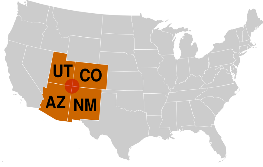
Much more than a survey marker where four states come together, the Four Corners region in the southwest U.S. is a reminder of how old our planet is. The wind and water have revealed its very bones and a visitor can feel the spirit of the ancient ones who lived here in centuries past.
Home to an Ancestral Puebloan culture that dates back a thousand years, the Four Corners today hosts a collection of architectural wonders that attract visitors from across the planet. Amidst the tablelands and canyons of the Colorado Plateau, the stories of the earth’s history and the history of the indigenous people who lived on it make for some great photographic imagery.
The daunting thing about shooting here is the region’s size. It’s big out here and if you don’t take the time to do your homework and some serious planning, you will find yourself too long on the road and not shooting often enough. On our recent trip, we narrowed our scope to a few key locations and then selected Farmington, New Mexico as our operations center.
Where To Stay
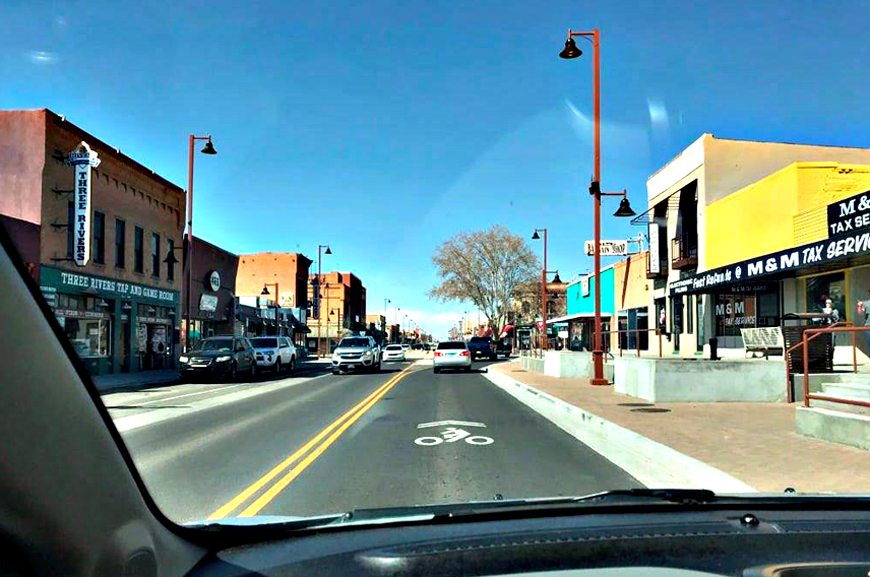
A town of almost 50,000, Farmington is a commercial hub for the region and offers plenty of lodging and restaurant options and a mesa-top commercial airport. Other hubs you might consider, depending on your photographic interests, include Durango, Cortez, or Grand Junction, Colorado; Flagstaff, Arizona; and Moab, Utah. All of these towns offer airport connections, food, lodging, and proximity to a number of Colorado Plateau features.
We chose Shiprock, Bisti/De-Na-Zin Wilderness Area, Chaco Cultural National Historic Park, Aztec Ruins National Monument, and Hovenweep National Monument as our main interests for the trip
. Our hub also provided us the option of visiting the spectacular and better-known Mesa Verde National Park.
Shiprock
Tsé Bitʼaʼí, or the ‘rock with wings’ in the Navajo language, Shiprock is a volcanic core, pushing up from the high desert plain to an elevation of nearly 7,200 above sea level. The wings -- walls of hard volcanic rock -- radiate from the upthrust neck. Located southwest of Shiprock, New Mexico, this iconic peak is near and dear to the Navajo for spiritual, cultural, and economic reasons.
Please Note: Photographs of Shiprock are allowed from Indian Service Route 13 or from US Highway 491, which runs south from the town of Shiprock. Driving on other reservation roads is not permitted without a Navajo guide. While Route 13 gets you closer to your subject, there are no pull-offs for scenic viewing, only small parking areas around turnoffs onto reservation roads. Drone photography also requires a permit from the Navajo Nation. Contacts for guides and other information are in the Resources section at the end of this article.
You’ll need a long lens for closeups of the peak and a wide-angle to get the spectacular dikes, or wings, that flow out from the center.
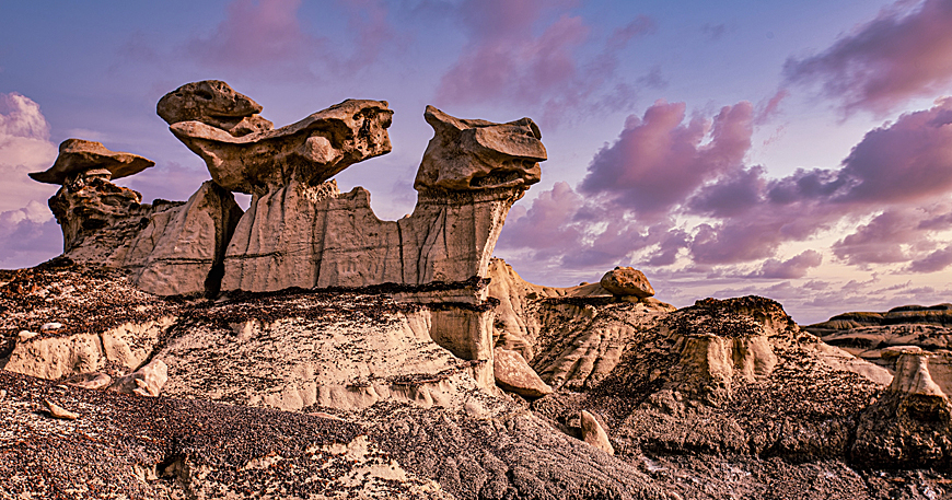
Bisti/De-Na-Zin Wilderness
A mystical hummocky desert of arches, hoodoos, wings of stone, and a variety of other shapes makes for photos bounded only by the imagination. A colorful geology -- formed from a 70-million-year-old shallow sea and river delta – has been transformed by erosion into a photographer’s adventureland. Dinosaurs roamed here and prehistoric swamps have been squ
eezed into present-day coalbeds. Mind the adventure, though. There are no real trails, no rangers, no reliable cell phone coverage, generally no water or shade. GPS or a good compass and topographical map may be your best companions here.
The Bisti and the De Na Zin are actually two different regions of the same continuous badland formation. The approach to the Bisti is from the west of the area and the De Na Zin trailhead is to the south. Farmington’s visitors bureau is a good place to start for information, maps, and videos on the badlands. Two other areas, Ah-Shi-Sle-Pah Wilderness Study Area and the Valley of Dreams offer similar creative photo opportunities in parts of the badlands best accessed from U.S. Highway 550, south of Bloomfield, NM.
Chaco Cultural National Historical Park
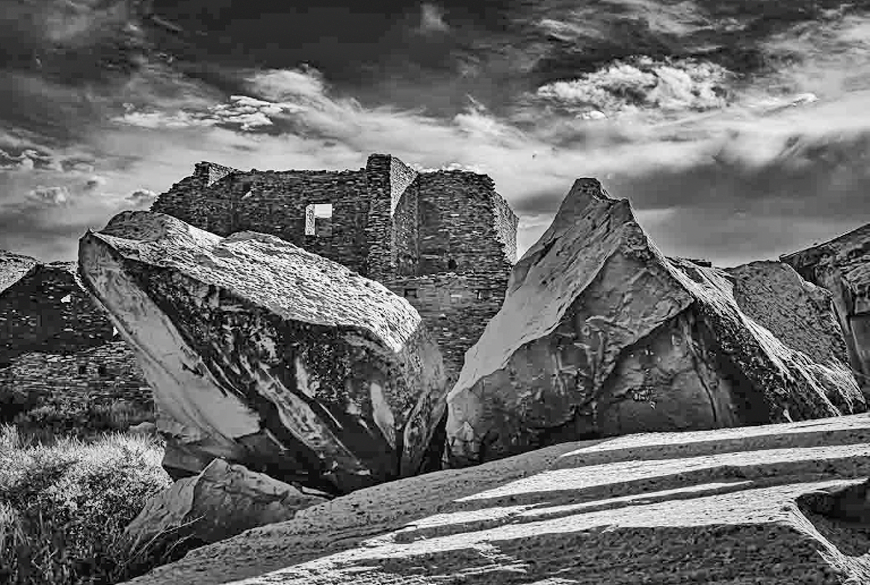
Remote and haunting,Chaco Canyon speaks to visitors in a way other Four Corners sites, with the crush of popularity , cannot. A ring road joins several villages and kivas, each with its own character and purpose. The most distinctive of these, Pueblo Bonito, offers photographers a walk around the perimeter and a chance to duck inside some of the rooms of this great abandoned village. The trails can be uneven, not suitable for some hikers, but rewarding.
Farmington and Bloomfield, New Mexico, offer the closest lodging and services to this remote site, which has been a tough visit in recent years due to the poor condition of the roads on the surrounding Navajo Reservation. Recent oil and gas prospecting and production in the area has resulted in improvement to the roads and most are easily passable by passenger cars in good weather. Access to the park is from U.S. 550, south of Bloomfield near the Nageezi trading post.
In recognition of the night sky observational skills of the ancestral pueblo people, the Park Service carries on regular astronomical programs and has its own observatory. Although the village sites are closed after sunset, opportunities do exist in the Dark Sky-designated park for astro photography.
Aztec Ruins National Monument
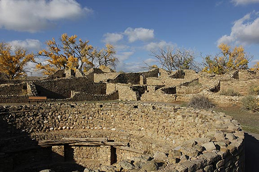
Minutes away from the picturesque downtown of Aztec, New Mexico, this national monument gives a glimpse of life in the twelfth century along the banks of the Animas River. One of the best preserved and restored of the Chaco Canyon outliers, visitors here can get a feel for everyday life by walking the village trail and visiting the museum. Some structures were under renovation during our 2024 visit, but there were still plenty of photographic opportunities.
One of the highlights at this site is a restored Great Kiva – a circular ceremonial structure offering insights into the craftsmanship of the people who built it and the religious ceremonies that took place there. Aztec is one of the most accessible Ancestral Puebloan sites, with wheelchair access to much of the main trail, picnic tables, restrooms, and close-in parking.
To be continued. Part 2 will follow.
RESOURCES:
– Shiprock Peak
https://navajonationparks.org/ For information on national and Navajo parks on Navajo lands.
https://navajonationparks.org/...
https://navajotoursusa.com/portfolio/shiprock-peak/ Shiprock Tours
https://discovernavajo.com/shiprock-peak/ Offering guides for Shiprock. This site also links to guides and tours for Bisti and other locations on Navajo lands.
-Bisti/De-Na-Zin Wilderness
https://farmingtonnm.org/listings/bisti-de-na-zin-wilderness This site offers videos and maps with information about several badland areas, including Bisti/De-Na-Zin.
-Chaco Cultural National Historical Park
https://www.nps.gov/chcu/index.htm Overview of the canyon and its various sites.
https://www.nps.gov/chcu/planyourvisit/nightsky.htm Information on night sky opportunities.
-Aztec Ruins National Monument
https://www.nps.gov/azru/index.htm Overview of the site.
https://en.wikipedia.org/wiki/Aztec_Ruins_National_Monument Historical information.
http://www.aztecnm.com/ Community information.
Original Publication Date: June 27, 2024
Article Last updated: June 30, 2024
Related Posts and Information
Categories
About Photographers
Announcements
Back to Basics
Books and Videos
Cards and Calendars
Commentary
Contests
Displaying Images
Editing for Print
Events
Favorite Photo Locations
Featured Software
Free Stuff
Handy Hardware
How-To-Do-It
Imaging
Inks and Papers
Marketing Images
Monitors
Odds and Ends
Photo Gear and Services
Photo History
Photography
Printer Reviews
Printing
Printing Project Ideas
Red River Paper
Red River Paper Pro
RRP Products
Scanners and Scanning
Success on Paper
Techniques
Techniques
Tips and Tricks
Webinars
Words from the Web
Workshops and Exhibits
all
Archives
January, 2025
December, 2024
November, 2024
October, 2024
September, 2024
August, 2024
July, 2024
June, 2024
May, 2024
more archive dates
archive article list


Red River Paper Inc. All contents © 1997 - 2025. 8330 Directors Row. Dallas Texas, 75247. Prices, specifications, and images are subject to change without notice. Not responsible for typographical or illustrative errors. Website Terms & Conditions | Acceptable Use
Site Development & Maintenance: Phosphor Media, LLC